Strong
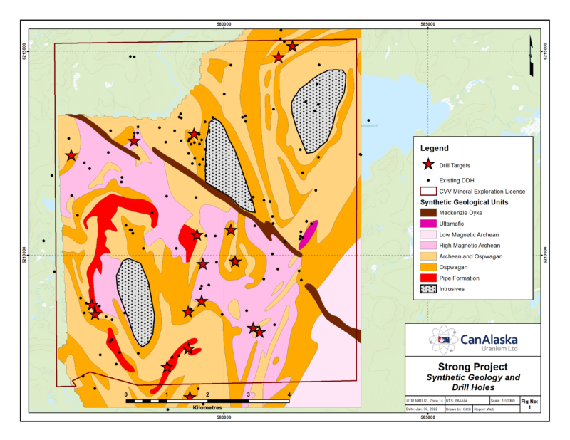
Location The Strong Project consists of one Mineral Exploration Licenses totaling 6,140 hectares, located 26km north of Thompson, Manitoba. Geology The TNB compilation in Figure 2 of the TNB shows the area to be underlain by Archean, Ospwagan Group with some ultramfics. Strong figure 1 shows a revised and more detailed geology interpreted from the […]
North Thompson
Location The Strong Extension (14,309ha), Moak North (6,025ha) and Wilson (5,272ha) are three Mineral Exploration Licenses applied for in October 2021, based on the data from a 2008 VTEM survey obtained by CanAlaska. They are located 35km northwest of Thompson, adjacent to highway 320. Geology The geology from the TNB compilation has been extended and […]
Manibridge
Location The Manibridge Project consists of 19 claims totaling 4,368 hectares, located 125km south west of Thompson, and 32km southwest Wabowden, Manitoba. It is accessible by road from highway 6. The claims contain the site of the reclaimed Manibridge Mine. Geology The area is part of the Thompson Nickel Belt and contains the same formations […]
Resting
Location The Resting property consists of eleven mineral claims with a total area of 2,322 hectares. It is located in the southern Thompson Nickel Belt 5 km south of Wabowden and the Bucko deposit and northwest of the Manibridge. Geology The Resting Ospwagan Group forms an elongated synform within Archean gneisses, both surrounded by a […]
Halfway
Location The Halfway property consists of eight mineral claims with a total area of 1,876 hectares. It is located in the southern Thompson Nickel Belt, 12km northeast of Wabowden and less than 2km from highway 6. Geology The Halfway property covers the north and the South of an Ospwagan synform within Archean basement. The core […]
Invera Reports Fourth Quarter 2021 Financial Results
Invera Group Inc. (NYSE: INV), a global provider of highly engineered products, differentiated industrial technologies, and innovative solutions, today reported financial results for the third quarter of 2022. “In the third quarter, Aerospace continued to deliver excellent performance driven by robust year-over-year growth in the Aftermarket business. At Industrial, performance remains challenged as persistent economic […]
NE Wollaston
Location The NE Wollaston projects consist of four claim groupings totalling 29,671 hectares, located 60 kilometres northeast of Cameco’s Rabbit Lake mill and Eagle Point mine (Figure 1). Geology The project areas cover the Collins Bay Fault, host to the Rabbit Lake, Collins Bay A, B and D, and Eagle Point orebodies, beyond the edge […]
Geikie
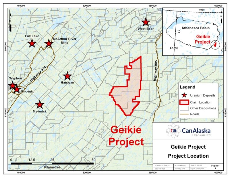
CanAlaska’s Geikie property, totaling 33,897 ha, is located 7 km Southeast of the present-day Athabasca Basin edge, in Saskatchewan, Canada. The property straddles the extension of a fertile corridor of biotite gneisses hosting the Agip S high-grade uranium showing (up to 58% U3O8), and the recent Baselode Energy radioactive intersections near Beckett Lake. These […]
Frontier
CanAlaska’s Frontier property, totaling 15,929 ha, is located in the northeastern Athabasca Basin. The project is five kilometres northeast of the present-day Athabasca Basin edge along the regional-scale Roughrider Mineralized Corridor (RMC). The RMC is host to multiple uranium deposits and showings, including Roughrider, Midwest, J Zone, Dawn Lake, Moonlight, Osprey, and the McClean Lake […]
Enterprise
CanAlaska’s Enterprise property, totaling 12,060 ha, is located in the southeastern Athabasca Basin. The project is twenty kilometres south of the present-day Athabasca Basin edge and the Key Lake Mine and Mill complex along Highway 914. Historical exploration on the project consists of prospecting and geological mapping that were completed in conjunction with airborne […]
North Millennium
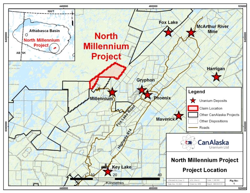
CanAlaska’s North Millennium property, totaling 5,873 ha, is located in the Eastern Athabasca Basin, Saskatchewan, Canada. The property is located seven km from Cameco’s Millennium uranium deposit. Northeast trending conductors on the project are disrupted and offset by a North-South trending lineament that can be traced down through the Millennium deposit. This North-South feature […]
McTavish
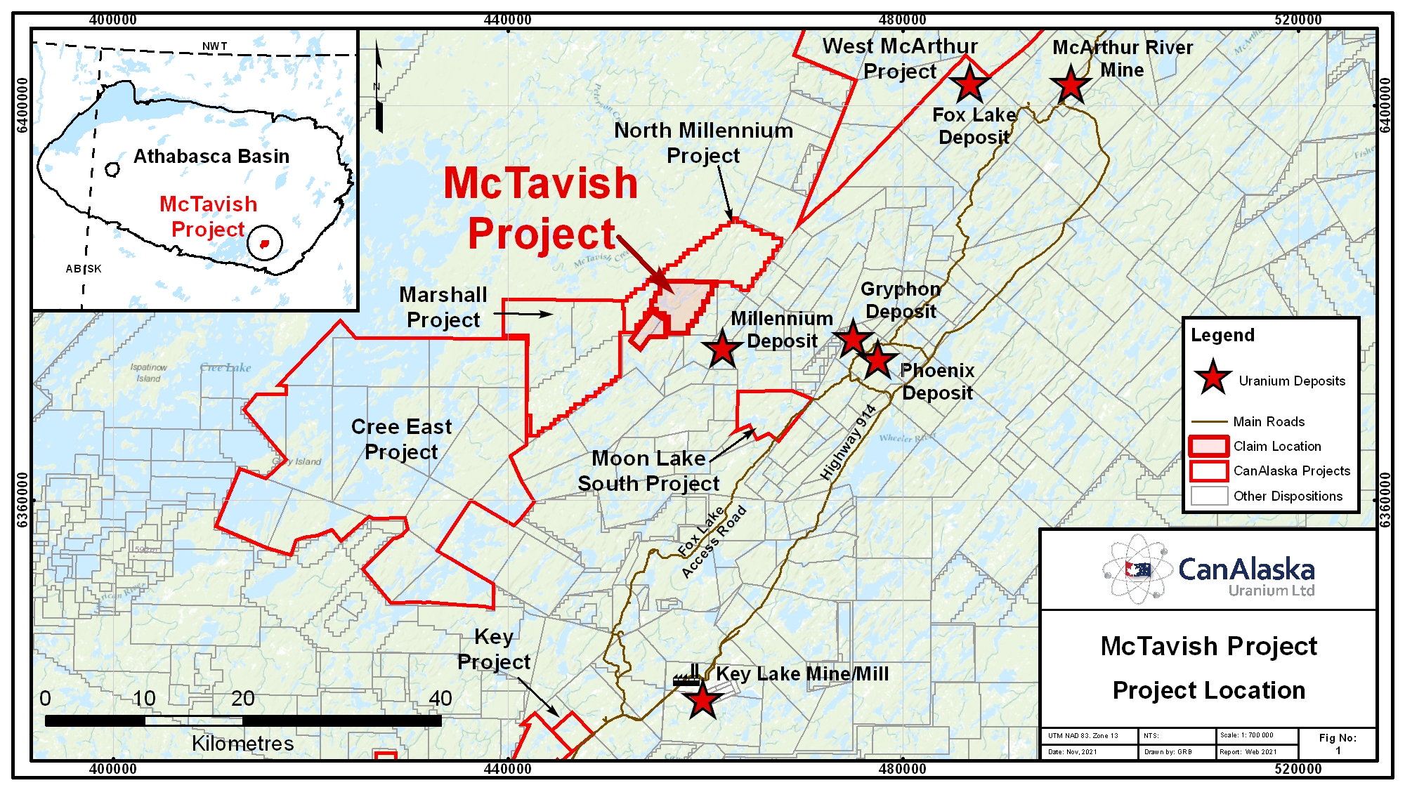
CanAlaska’s McTavish property, totaling 2,685 ha, is located in the Eastern Athabasca Basin, Saskatchewan, Canada. The project is located 5 km northwest of Cameco’s Millennium uranium deposit. The project area has been periodically explored for unconformity-type uranium deposits since the late 1970’s with work on and adjacent to the project consisting of airborne and […]
Marshall
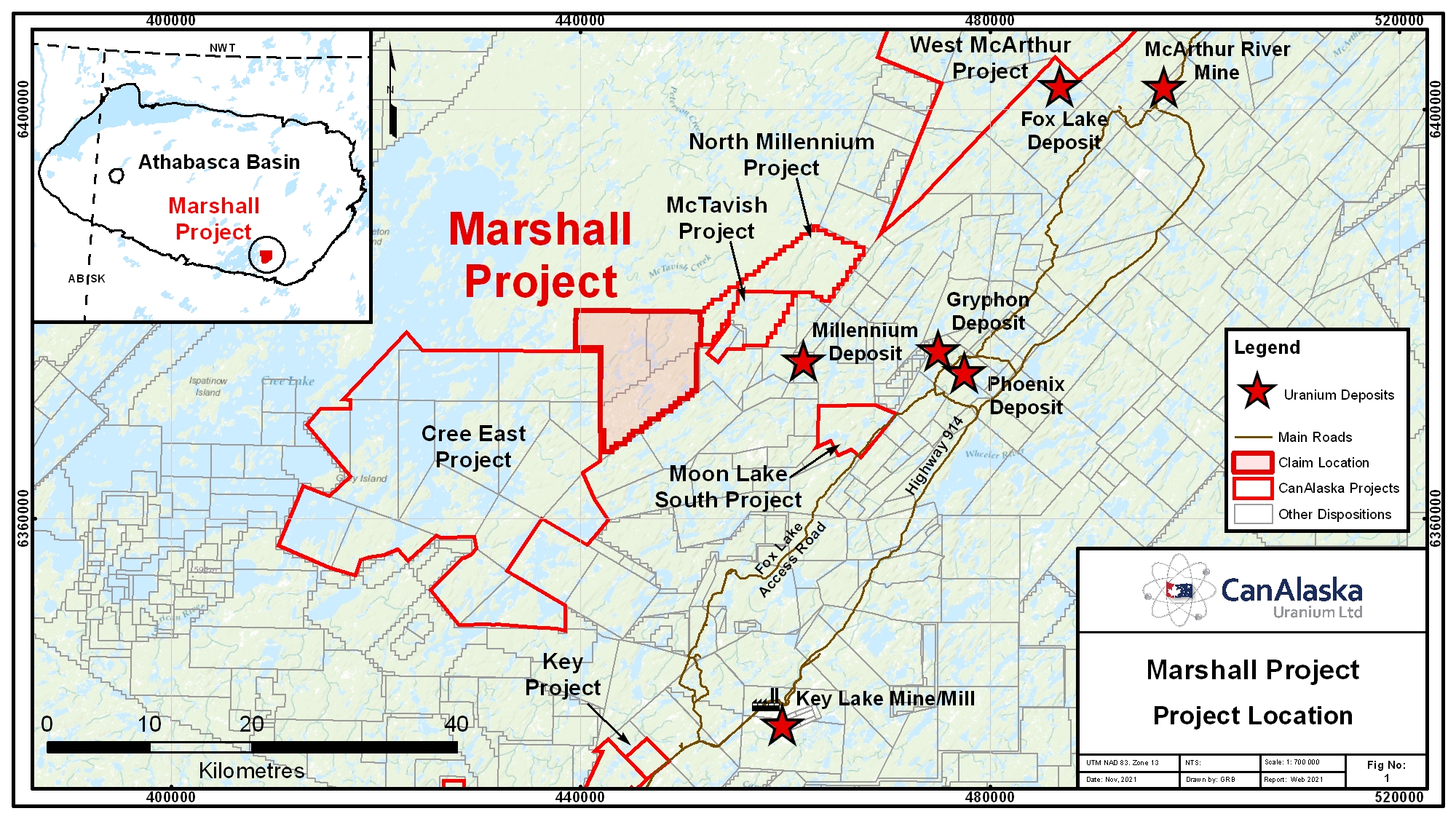
CanAlaska’s Marshall property, totaling 11,225 ha, is located in the Eastern Athabasca Basin, Saskatchewan, Canada. The project is 11 km west of Cameco’s Millennium uranium deposit. The project area has been subject to minimal historical exploration for unconformity-type uranium deposits, mainly centered airborne and ground geophysical surveys, and boulder prospecting. No diamond drilling has […]
Chymko
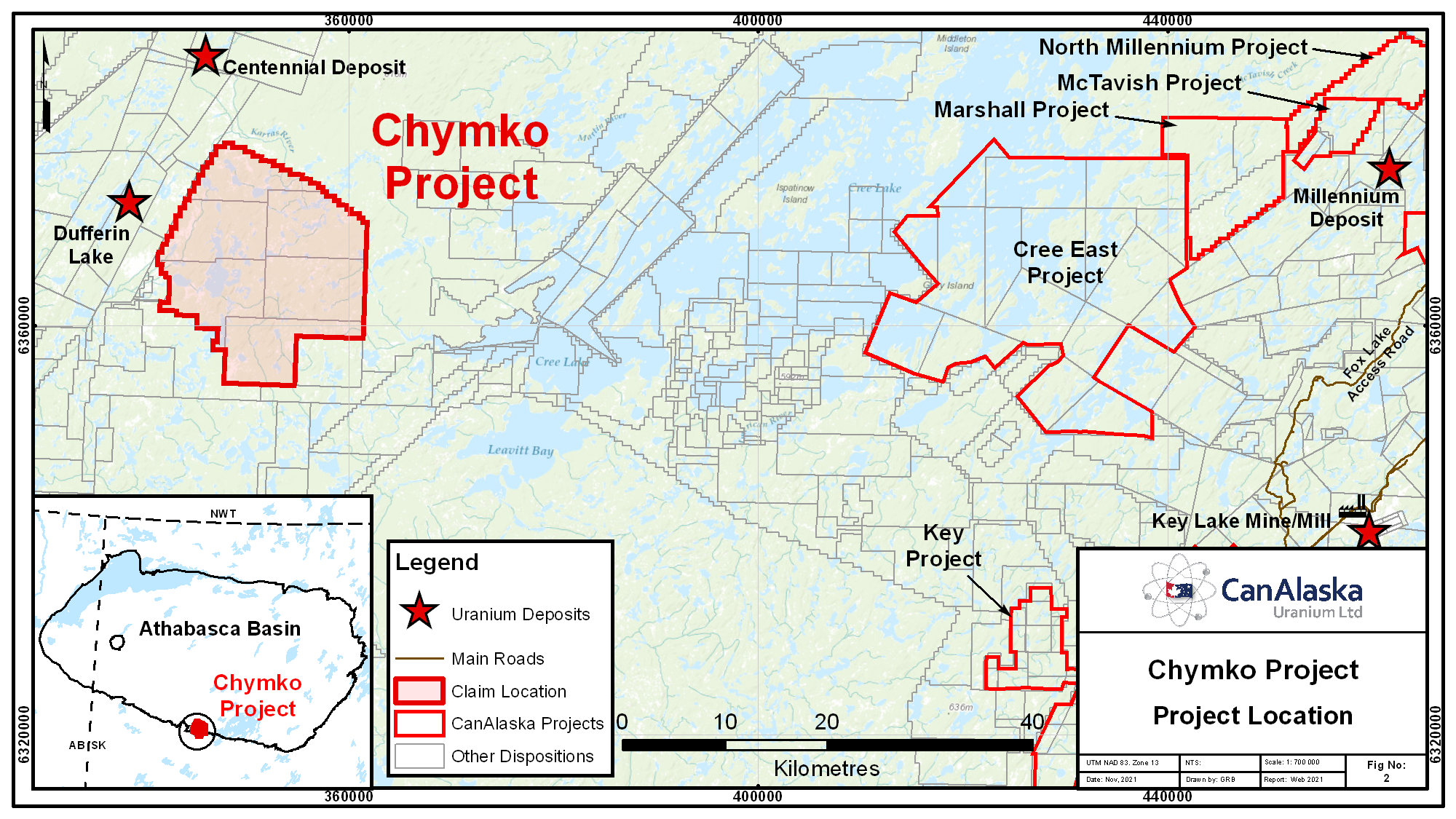
CanAlaska’s Chymko property, totaling 32,603 ha, straddles the south-central edge of the present-day Athabasca Basin in Saskatchewan, Canada. The property is adjacent to the Virgin River Shear Zone, which hosts the Centennial and Dufferin Lake unconformity uranium deposits. The project area has been historically explored by regional airborne geophysical and ground lake sediment surveys. […]
Carswell
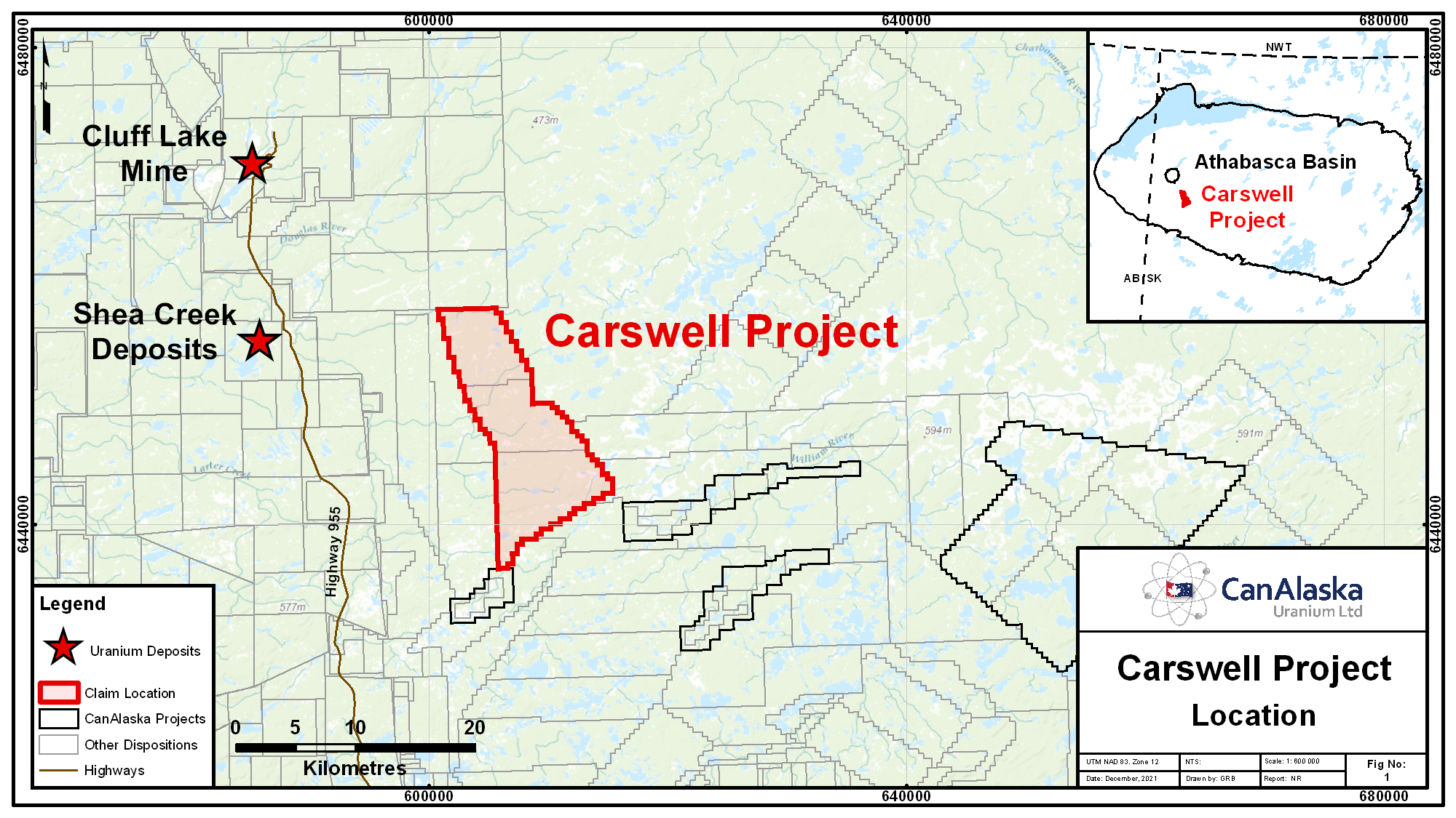
CanAlaska’s Carswell property, totaling 13,352 ha, is located in the western Athabasca Basin, Saskatchewan, Canada. Within the western Athabasca Basin, some of the most significant undeveloped uranium resources exist in the Shea Creek, Triple R, and Arrow deposits. The property covers a conductive structural corridor that joins the Beatty River fault zone to Carswell […]
Moon Lake South
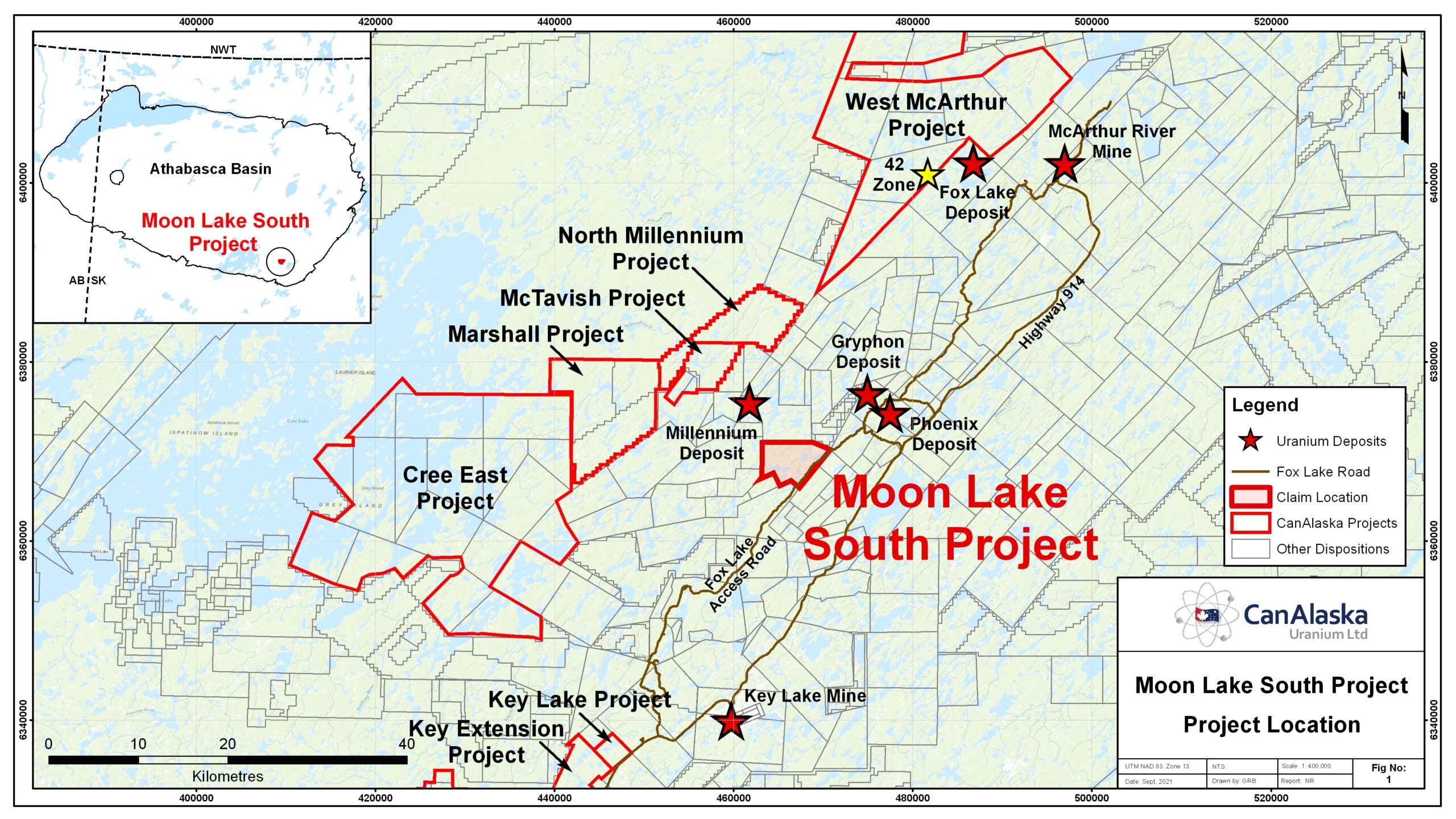
CanAlaska holds a 25% ownership in the Moon Lake South JV operated by our partner Denison Mines Corporation. The property is host to a five km long Northeast trending conductive corridor known as the CR-3 conductor. The CR-3 conductor is located two kilometres west of the K-trend, host to the Gryphon Deposit on Denison’s […]
Taggart
CanAlaska’s Taggart property, totalling 28,328 ha, is located in the western Athabasca Basin, Saskatchewan, Canada. The property is 60 km northeast of the Triple R and Arrow uranium deposits along the mineralized Patterson Lake Corridor. Geophysical and geological compilation work suggest that the basement rocks of the Patterson Lake Corridor, consisting of granitic to […]
NW Manitoba
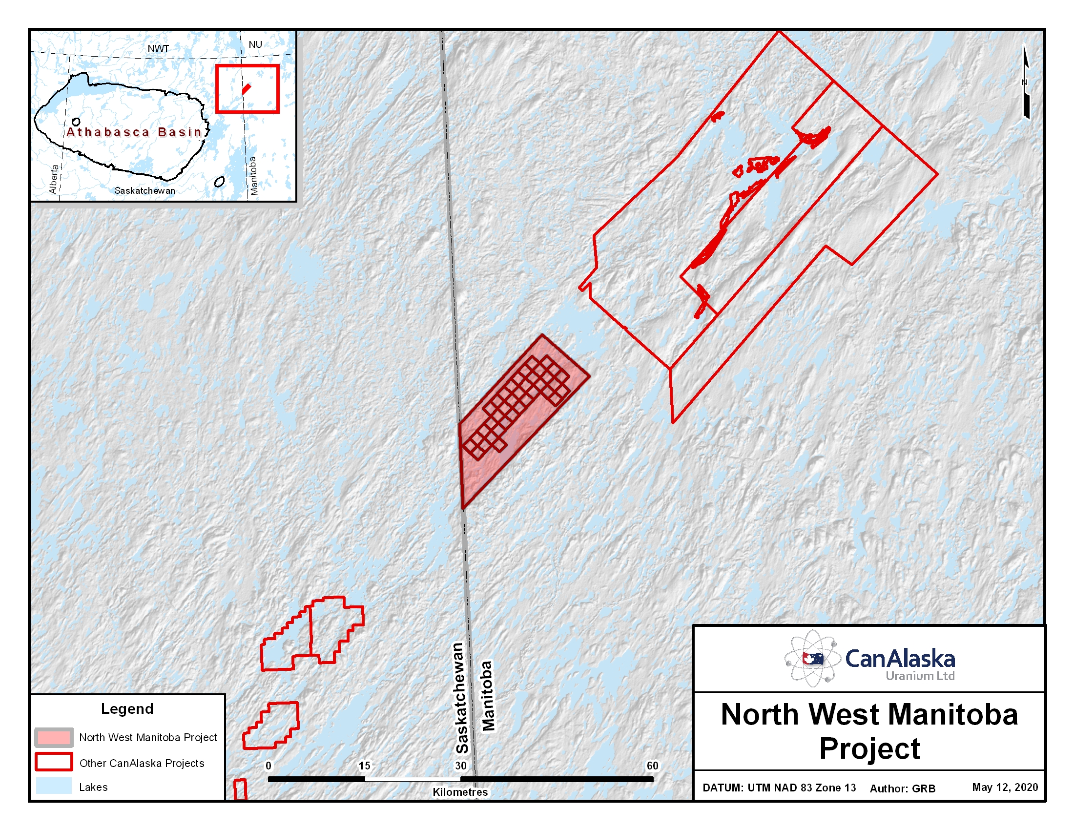
Location The project lies in northwest Manitoba just east of the border of northeast Saskatchewan. It is 70 km north of Reindeer Lake and covers 143,603 hectares. The project has similar geology to areas which include the Rabbit Lake, Collins Bay and Eagle Point Uranium mines 90 kilometres to the South West. Geology The […]
Patterson West Project
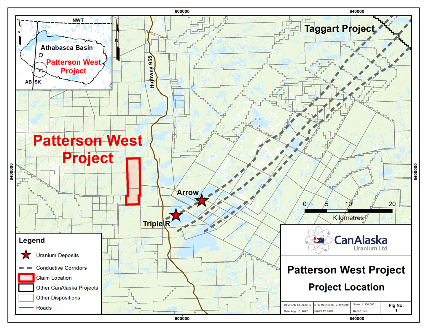
CanAlaska’s Patterson West property, totaling 3,015 ha, is located in the Patterson Lake area of the Athabasca Basin. The project straddles the southwestern edge of the present-day Athabasca Basin in Saskatchewan Canada. The Patterson West project is located 10 – 15 km west of the Triple R and Arrow uranium deposits. A VTEMmax airborne […]
Watson
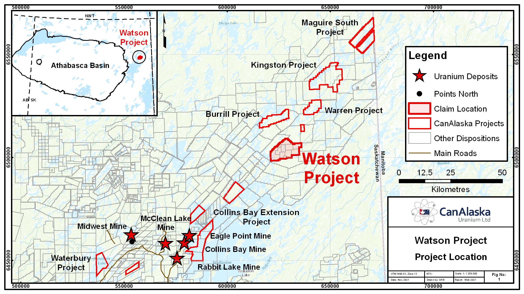
CanAlaska’s Watson property, totaling 10,085 ha, is located 55 km from the northeastern margin of the present-day Athabasca Basin, Saskatchewan, Canada. The Watson project is part of CanAlaska’s NE Wollaston land package, where the main target is basement-hosted uranium deposits similar to Eagle Point or Arrow. The project is located on a portion of a […]